Indigenous Cartography and
Cartography of the Indigenous
Cartography of the Indigenous
Fixico, Donald L. (2004). "Trail of Tears, the routes taken by the Cherokee, Choctaw, Chicksaw, Creek, and Seminole when they were forced to move west in the early 19th century [map]." Figure 1 for "History of the Western Southeast Since Removal" in R. D. Fogelson (Ed.), Handbook of North American Indians: Southeast (Vol. 14, pp. 162-173). Washington D.C.: Smithsonian Institution.
"Ancestral archaeological sites found throughout Hopitutskwa constitute monuments by which the Hopi people verify their clan histories and religious beliefs." (Kuwanwisiwma and Ferguson 2014, p. 133)
"The Hopi land is the Hopi religion." (Kuwanwisiwma and Ferguson 2014, p. 133)
Sutton, D. (2014). "Hopitutskwa [map]." Figure 35.1 in "Hopitutskwa: The Meaning and Power of Maps" Kuwanwisiwma, L. and Ferguson, T. in Mapping Native America: Cartographic Interactions between Indigenous Peoples, Government, and Academia (Vol. 3, p. 136), Cole, D. G. & I. Sutton (Eds.). North Charleston: CreateSpace Independent Publishing Platform.
... points, lines, polygons ...
"Any attempt to delineate a single set of boundaries for Hopitutskwa thus conflicts to some degree with the reality of how knowledge is distributed and used for religious purposes within the Hopi Tribe." (Kuwanwisiwma and Ferguson, p 142)
"... the Hopis and their ancestors have used land in areas far beyond the depicted boundaries, the cartographic image of Hopitutskwa is often more powerful than the written narrative." (Kuwanwisiwma and Ferguson, p 143)
Kuwanwisiwma, L. and Ferguson, T. (2014). "Hopitutskwa: The Meaning and Power of Maps" in Mapping Native America: Cartographic Interactions between Indigenous Peoples, Government, and Academia (Vol. 3, p. 132-147), Cole, D. G. & I. Sutton (Eds.). North Charleston: CreateSpace Independent Publishing Platform.
Sutton, D. (2014). "Hopi Partition with Adjudicated Areas [map]." Figure 35.2 in "Hopitutskwa: The Meaning and Power of Maps" Kuwanwisiwma, L. and Ferguson, T. in Mapping Native America: Cartographic Interactions between Indigenous Peoples, Government, and Academia (Vol. 3, p. 139), Cole, D. G. & I. Sutton (Eds.). North Charleston: CreateSpace Independent Publishing Platform.
property
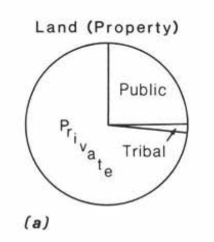
Sutton, I. (1991). “Preface to Indian Country: Geography and Law,” American Indian Culture and Research Journal, 15(3): 3–35.
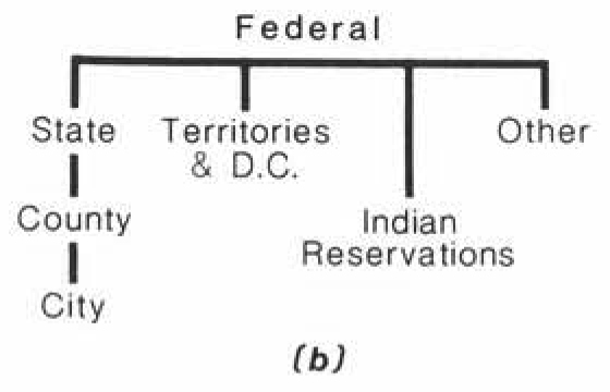
jurisdiction

Sutton, I. (1991). “Preface to Indian Country: Geography and Law,” American Indian Culture and Research Journal, 15(3): 3–35.
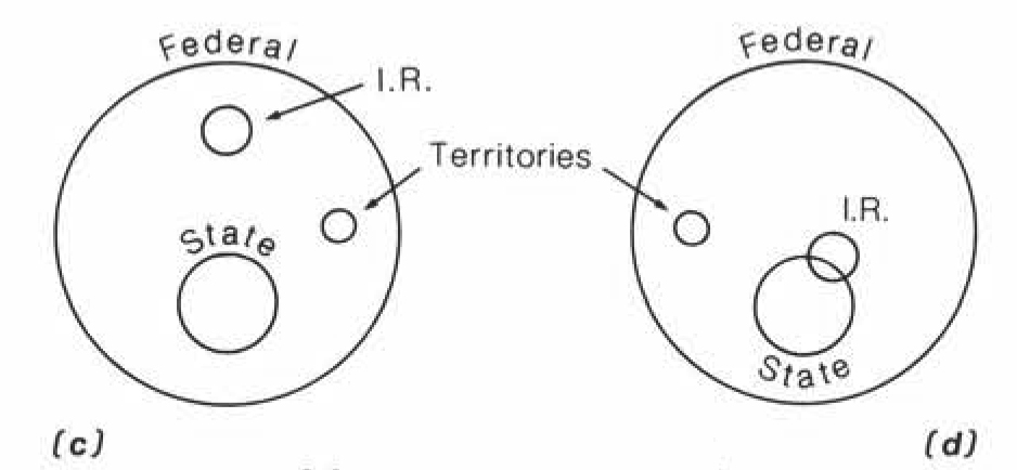
Indian Country I
(A Legal/Proprietal View)
(A Legal/Proprietal View)
Sutton, I. (1991). "Indian Country I (A Legal/Proprietal View) [map]." Figure 2 in “Preface to Indian Country: Geography and Law,” American Indian Culture and Research Journal, 15(3): p 9.
Indian Country
"Indian Country is about as provisional as "Marlboro country," that is, it is an image, or a state of mind, or a sociological phenomenon to many. Indian country is an incredibly complex jurisdictional issue disguised in a colorful phrase" (Ragsdale 1985 as cited in in Sutton, I. 1991, p. 10).
"That the idea moved from a popular conception to a highly technical legal term is testimony to the ability of the law to incorporate customs within its intellectual framework (emphasis added)" (Deloria and Lytle 1983 as cited in Sutton, I. 1991, p. 10)
Sutton, I. (1991). “Preface to Indian Country: Geography and Law,” American Indian Culture and Research Journal, 15(3).
Deloria, V. and Lytle, C. (1983). American Indians, American Justice. University of Texas Press, Austin.
Ragsdale, F. (1985). "The Deception of Geography" in American Indian Plicy in the Tewntieth Century, Deloria, V. (ed). University of Oklahoma Press, Norman.
Deloria, V. and Lytle, C. (1983). American Indians, American Justice. University of Texas Press, Austin.
Ragsdale, F. (1985). "The Deception of Geography" in American Indian Plicy in the Tewntieth Century, Deloria, V. (ed). University of Oklahoma Press, Norman.
Indian Country II
(A Ethnohistorical View)
(A Ethnohistorical View)
Sutton, I. (1991). "Indian Country II (A Ethnohistorical View) [map]." Figure 3 in “Preface to Indian Country: Geography and Law,” American Indian Culture and Research Journal, 15(3): p 13.
Indian Country III
(A Political/Geographical View)
(A Political/Geographical View)
Sutton, I. (1991). "Indian Country III (A EPolitical/Geographical View) [map]." Figure 3 in “Preface to Indian Country: Geography and Law,” American Indian Culture and Research Journal, 15(3): p 20.
Sutton, I. (1991). "Toppenish, Takima Indian Reservation" Photo 2 in “Preface to Indian Country: Geography and Law,” American Indian Culture and Research Journal, 15(3): p 28.