ARC 594/694 - Geographic Information Systems in Urban Design
|
Tool of Statecraft
as far back as Rome
|
 |
Estate map
late 13th or 14th C onwards
|
Palomino, Diego (1549). Traça de la conquista del capitán Diego Palomino: [de las Relaciónes Geográficas, Provincia de Chuquimayo, Perú]
Kain, R. J. P., & Baigent, E. (1992). The Cadastral Map in the Service of the State: A History of Property Mapping. Chicago: University of Chicago Press.
Timothy B Norris, PhD
Christopher Mader
You can follow along at:
https://tibbben.github.io/geospatial-visualization/
ARC 594/694 - Geographic Information Systems in Urban Design
|
Telling Stories
starting conversations
|
 |
Online Mapping Platforms
21st century and onward
|
Mader, Chris (2018). Drone Survey of Las Flores, Barranquilla, Colombia.
- what is a map?
- what is GIS?
- what is cartography?
- what is geospatial analysis?
- what questions can I ask with GIS?
- what stories can I tell with GIS?
- Maps tell stories ...
... the story is about place and space - Maps are representations of reality
Location and attributes: spatial relationships
- Maps are performances
... and they have purpose - Maps are abstractions
symbolization and generalization
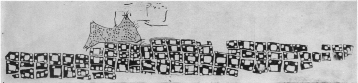
The 6200 BC “map” of Çatalhöyük in Turkey
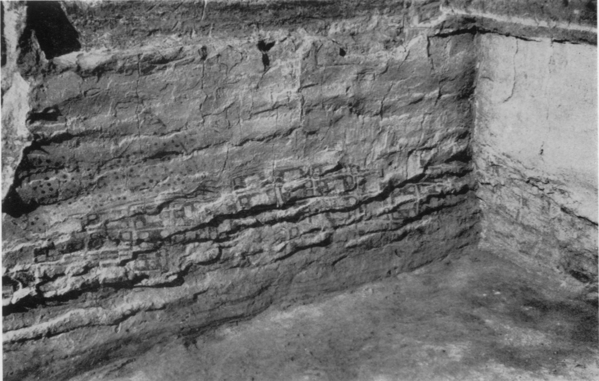
Is this a Map?
National Geographic made the map of the US based on translations of place names from their origins in Native American languages.
Hereford Mappa Mundi, Richard of Haldingham and Lafford, c 1300
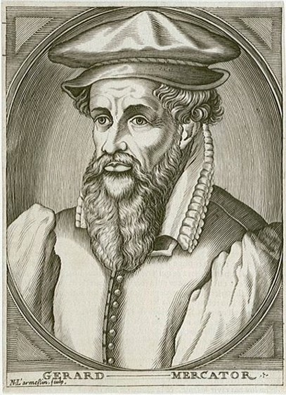
Gerhard Mercator, 1569
Napoleon's march on Moscow March 1812, Charles Joseph Minard
When a large outbreak occurred in London in 1854, Dr. John Snow created a map that settled a debate between two schools of thought: that cholera is transmitted not through the inhalation of infected air, but through the ingestion of contaminated water or food.
map credit: infrapedia
- What stories will you tell with maps?
- Tension between fiction and reality, map and territory
- The critical turn in cartography - maps and power
- Story (imaginative) vs. grid (lack of imagination)
- Maps as navigational tools for data as well as the world
- Maps are more interesting than reality?
- Web 2.0 and the geospatial turn - "easy maps"
- Definition of GIS - 'S' for system
- "Crowdsourcing" as a data collection method; "citizens as sensors" (Goodchild)
- New assemblages of data, people, machines and code revisit old questions about maps
- "Naive" geography and vernacular development
- Public participation in GIS - P/PGIS
Sui, Daniel. 2008. "The Wikification of GIS and its Consequences or Angelina Jolie's New Tattoo and the Future of GIS." Computers, Environment and Urban Systems 32:1-5. DOI: 10.1016/j.compenvurbsys.2007.12.001.
- Geographic Information System
- collections of tools, data, hardware, and people
- Geographic Information Science
- systematic inquiry into research questions about the relationship between GIS and socio-natural systems
- Geographic Information conStruction
- tool building for storage, collection or analysis of geospatial data
Wright, D. J., Goodchild, M. F., & Proctor, J. D. (1997). Demystifying the Persistent Ambiguity of GIS as ‘Tool’ versus ‘Science’.
Annals of the Association of American Geographers, 87(2), 346-362. doi:10.1111/0004-5608.872057
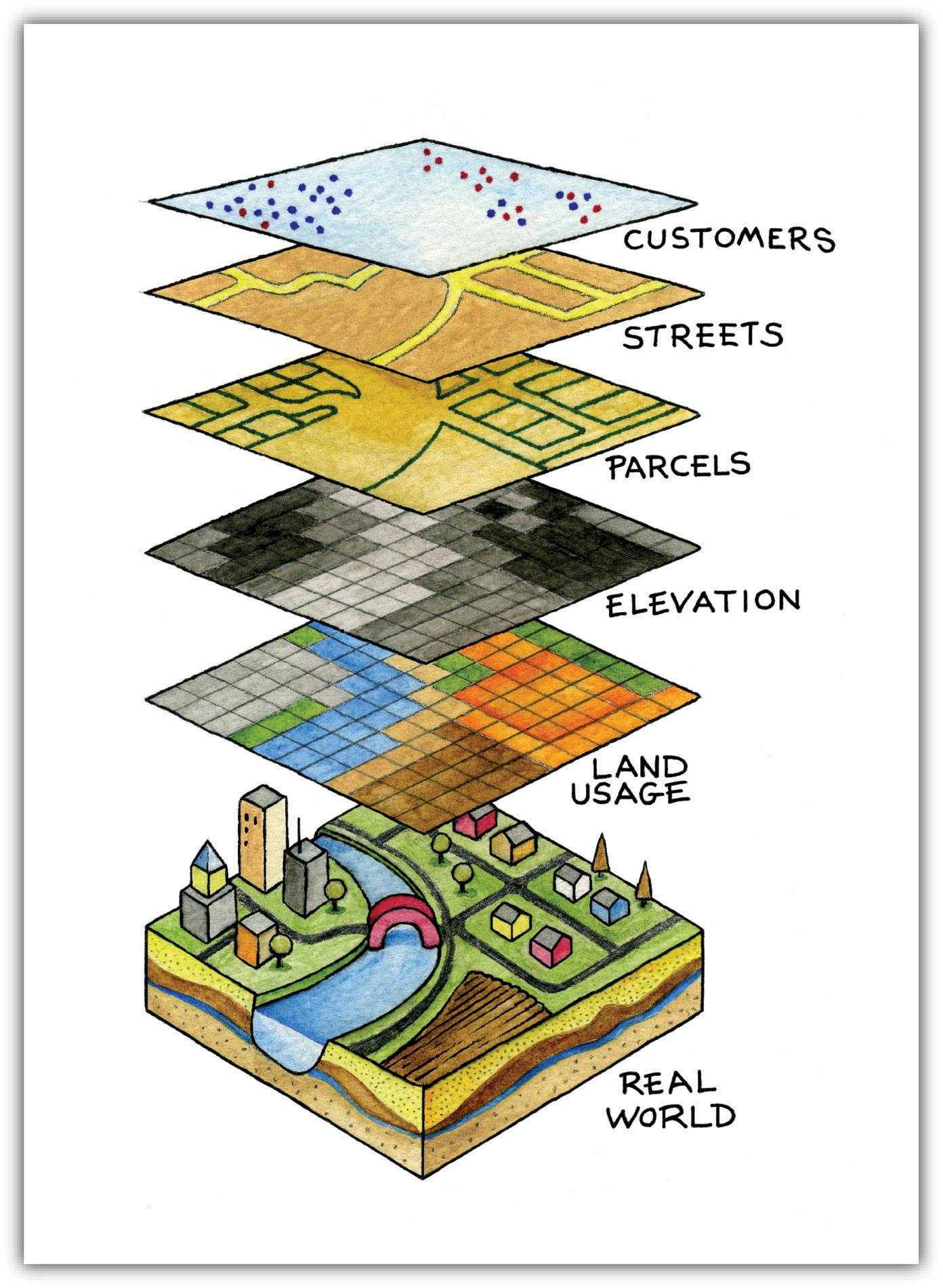
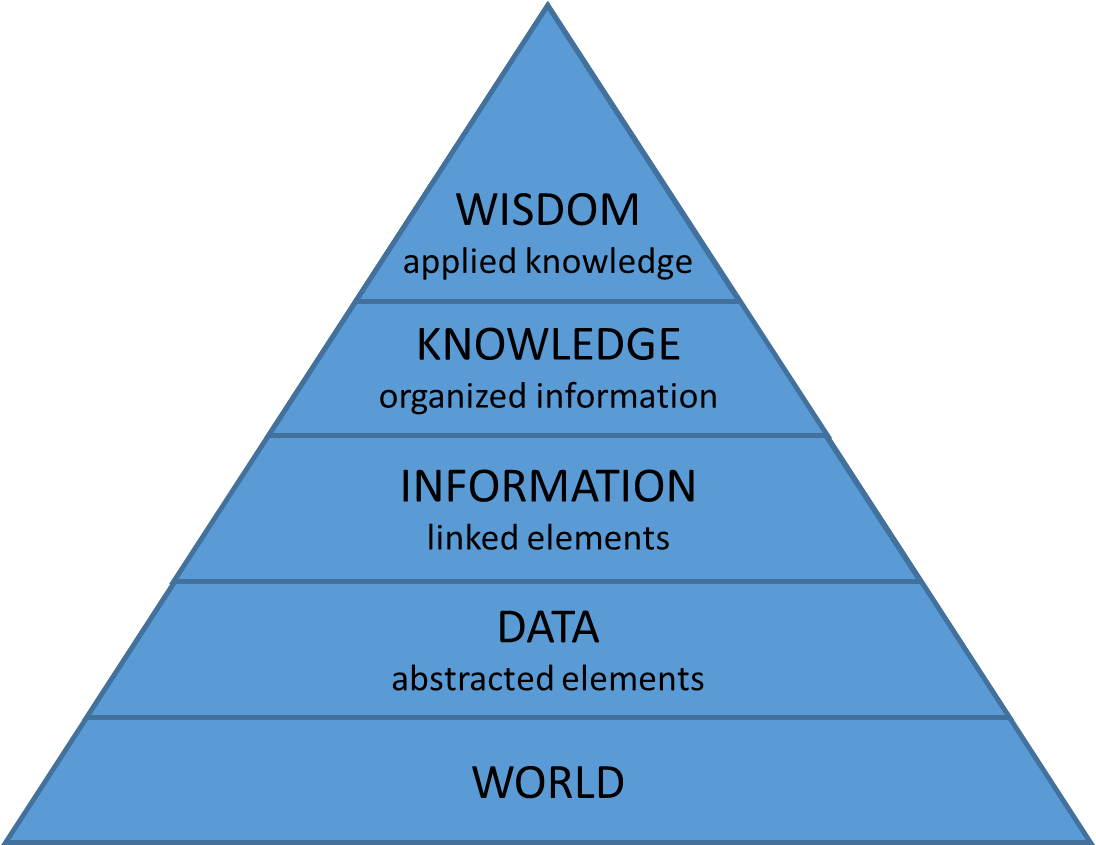
The system of organization can be digital (software) or analog (drawn on paper).
The actual process of organization is done with a purpose by human beings.
- Physical Data Model
(files on disk) - Logical Data Model
(data structures - vector and raster) - Conceptual Data Model
(discrete or continuous) - Reality
(the world out there)
- where?
- what (who)?
- how much?
- extent or area?
- [ when? ]
- distance between (travel time)?
- path of least resistance (route)?
- overlap of areas (jurisdictions)?
- areal statistics (demographics)
- land use / land cover change
- clusters (spatial statistics)
- interpolation
- [ why? ]
- watersheds (flows)
- traffic patterns
- pollution
- viewsheds
- geo-fencing (buffers)
- scope of question (is it doable)
- scale and type of output (design question)
- visualization (print, online, etc)
- how will you get the data!!!
- Tool set
- collection of software programs
- in some cases referred to as a stack
- Data model
- Relational databases (tables)
- Extensible/hierarchical data models (trees)
- Raster data (grids and images)
- Scripting languages
- Tool set
- ArcGIS Desktop
- ArcGIS Pro *NEW*
- Relational data model
- shapefiles (.shp)
- geodatabases (.gdb)
- geotiffs (.tif)
- database servers (SQLServer, postgreSQL)
- Scripting languages
- python
- Tool set
- QGIS - http://www.qgis.org/en/site/
- base: Geospatial Data Abstraction Library (GDAL)
- base: Open GIS Reference (OGR)
- Relational data model
- shapefiles (.shp), raw text (.csv)
- geojson (.json)
- geotiffs (.tif)
- database servers (postgreSQL, oracle)
- Scripting languages
- python
- Tool set
- R - https://www.r-project.org/
- packages: maps, ggplot2, sp
- leaflet for visualization
- Physical and logical data models
- raw text, csv (tables)
- raw text, json (trees)
- raw text, grids (raster)
- relational databases (sql)
- Scripting languages
- R
- University of Miami Resources
- for library GIS resources see http://sp.library.miami.edu/subjects/gis
- in the Geography department contact Chris Hanson (lab manager) hansonc@miami.edu
- for ArcGIS Pro contact Maria L. Estevanez (RSMAS) mestevanez@rsmas.miami.edu
- for FOSS and advanced GIS contact Timothy Norris (UML/CCS) tnorris@miami.edu
- Tool set
- ArcGIS Online
- ESRI Storymap
- ArcGIS for Server - for serving data and images
- Relational data model
- feature services (ArcGIS Online)
- database servers (SQLServer, posgreSQL)
- Scripting languages
- not really any
- Tool set
- MapServer - http://mapserver.org/
- base: Geospatial Data Abstraction Library (GDAL)
- base: Open GIS Reference (OGR)
- Relational data model
- shapefiles (.shp)
- geotiffs (.tif)
- Scripting/programming languages
- c++ family
- python, ruby, php
- Tool set
- Google Earth - https://www.google.com/earth/
- table data model
- Keyhole Markup Language (KML)
- Scripting languages
- javascript
- Tool set
- Leaflet - http://leafletjs.com/
- HTML - javascript - CSS
- tree and raster only
- json, kml (trees)
- jpg, png, etc (raster)
- Scripting/programming languages
- javascript (front end)
- anything (backend)
- ESRI storymap - we have this here on campus - https://storymaps.arcgis.com/
- example: Taxi Cab Terrain
- for an account contact Abraham Parrish (GIS Librarian): aparrish@miami.edu
- [ storymap.js - https://storymap.knightlab.com/ ]
- Tool set
- No standard toolset ...
- ... Jupyter notebooks or R Studio
- relational data model
- NetCDF grids and vectors) (.nc)
- Raster (.geotiff, .jpg, .png, etc)
- raw text (.csv, .json, etc)
- Scripting/programming languages
- python
- R
- sql
- Available at the University of Miami
- Pegasus - https://idsc.miami.edu/pegasus/
- interested? create an IDSC account
- Directory Structure
- File Naming Convention
- Take a moment, think about your file naming for your articles that you save
- Are you consistent?
- Is it easy to find what you want several months later?
- Now think about your file structure for your downloaded articles
- Where are the actual files on the computer?
- How many folders are you using?
- Are they logically organized?


[ best practices ]
- useCamelCasing.docx
- use_underscores.txt
- 2015_put_The_Date_First.csv
- 20150214_useTwoDidgitDateNumbers.xls
- startASeriesWithLeadingZeros_001.doc
- 20150214_UM_date-place.shp
- useFileExtensions.jpg
- Leave spaces in the file name.xls
- Use the default save name from MS word that is simply the long first sentence in your file.doc
- January 5 2015 Samples with the month first.xls
- Label as final version.doc
- "special characters: & , * % # ; * ( ) ! @$ ^ ~ ' { } [ ] ? < > - + /"
- No more than about 25 characters

[ best practices ]
- useCamelCasing.docx
- use_underscores.txt
- 2015_put_The_Date_First.csv
- 20150214_useTwoDidgitDateNumbers.xls
- startASeriesWithLeadingZeros_001.doc
- 20150214_UM_date-place.shp
- useFileExtensions.jpg
- Leave spaces in the file name.xls
- Use the default save name from MS word that is simply the long first sentence in your file.doc
- January 5 2015 Samples with the month first.xls
- Label as final version.doc
- special characters: & , * % # ; * ( ) ! @$ ^ ~ ' { } [ ] ? < > - + /
- No more than about 25 characters
- If all project files can reasonable fit in one folder ...
- Good for sharing projects
- If you have lots of data that gets shared across projects ...
- Bad for sharing projects
- Good for data re-use across projects